


The small plane taxied along the runway after taking off from Pisco’s tiny airport. It’s time to explore one of Peru’s greatest mysteries, the Nazca Lines.
Located in the high desert and stretching across 190 square miles, these handmade features on the earth’s surface, called geoglyphs, are the most outstanding creation that cannot be found anywhere else in the world. The best part is that they can only be seen entirely from the air.
From 200 BCE to 600 CE, the Nazca civilisation flourished on the southern coast of present-day Peru. They are known for their contribution to producing high-quality ceramics and textiles and creating the infamous Nazca Lines. Discoveries have also attributed some geoglyphs to the Paracas culture, which predates the Nazca Lines by a thousand years.
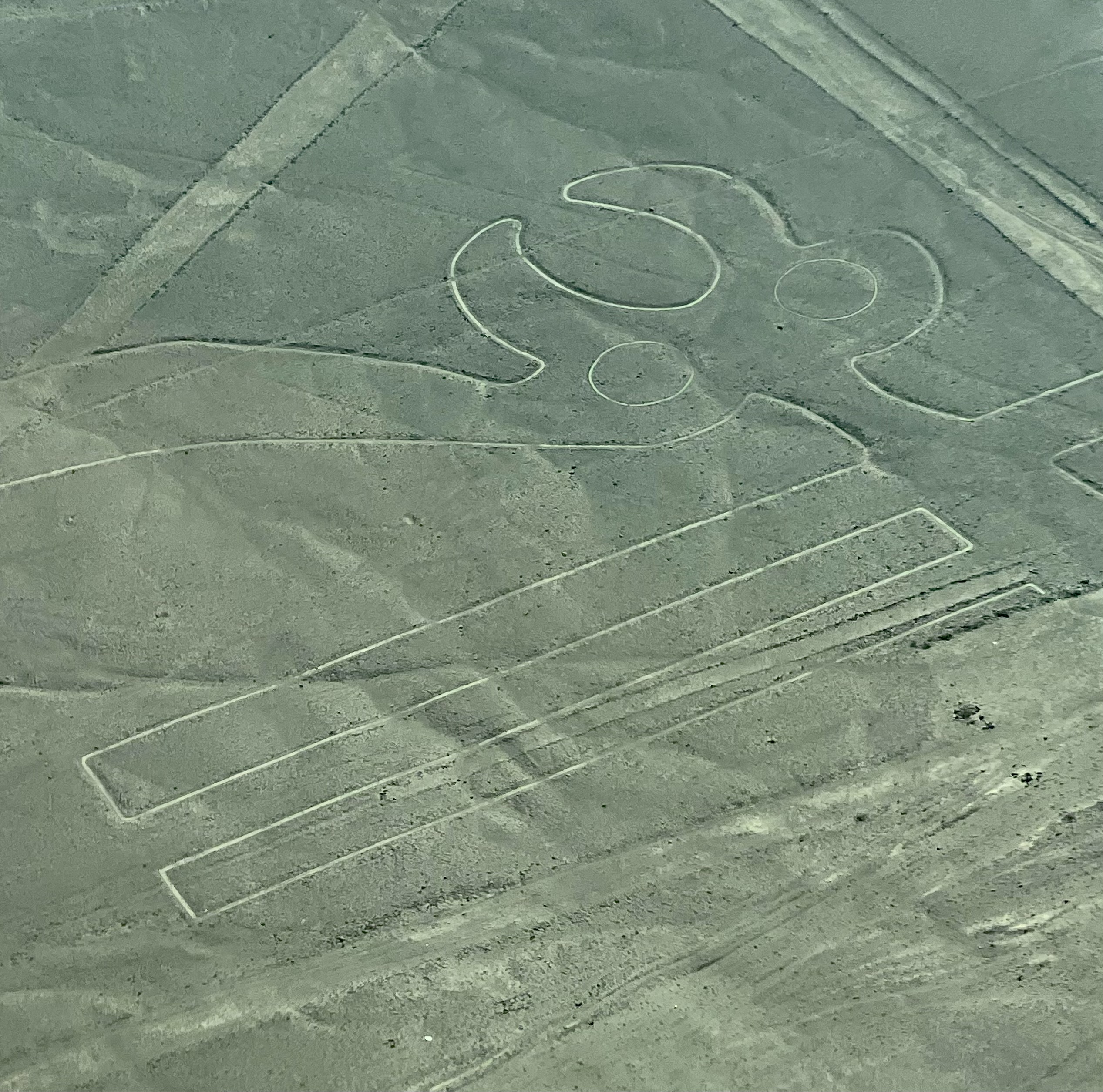
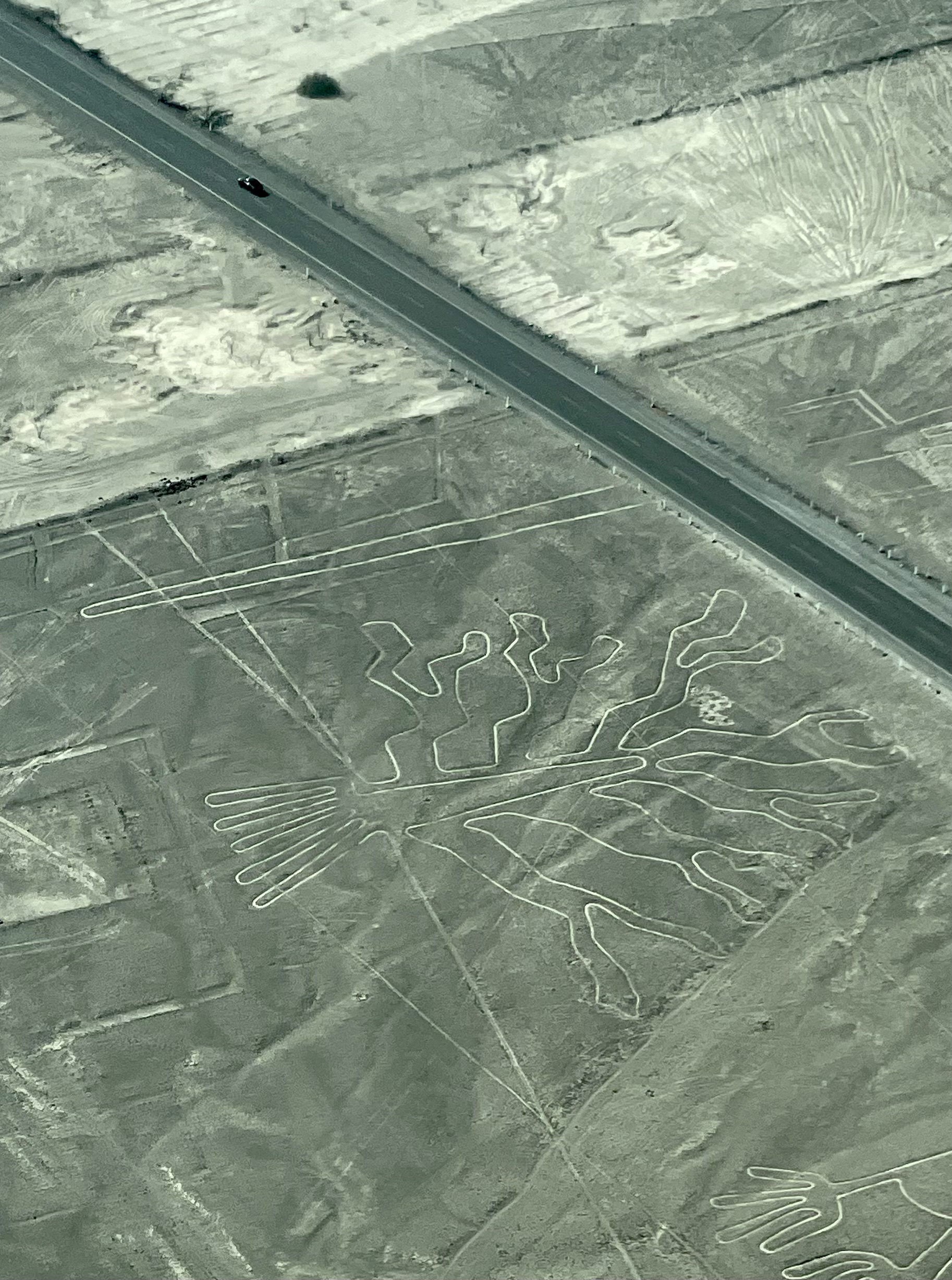
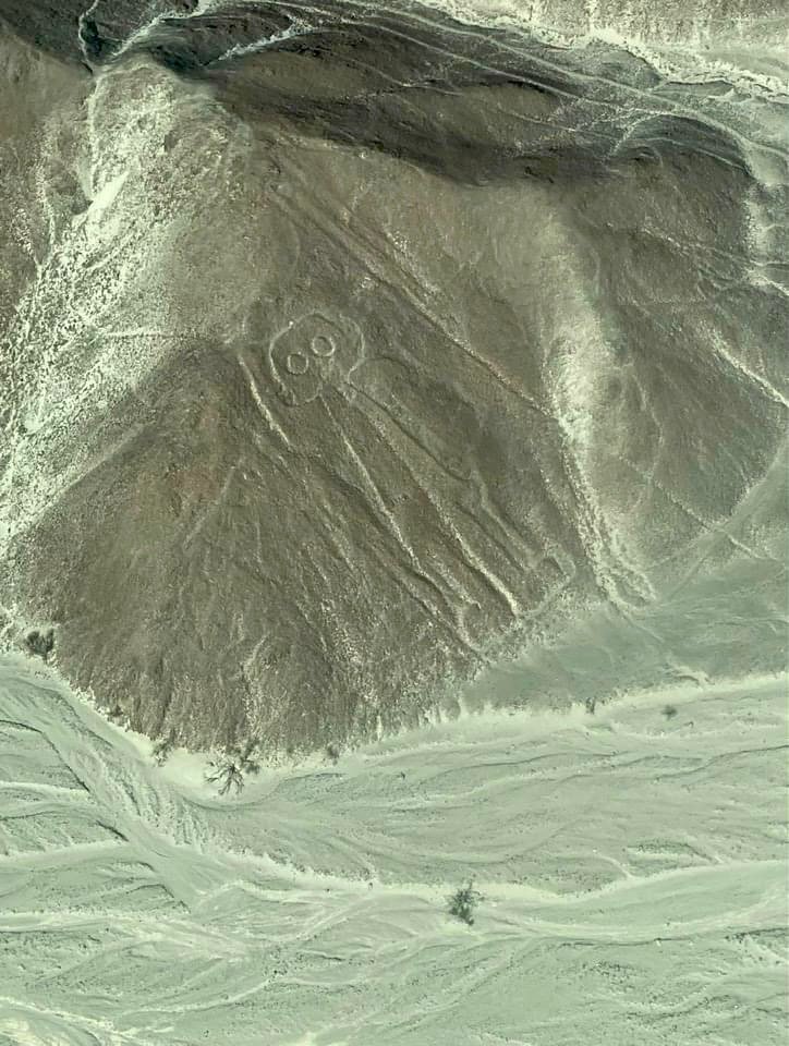
Three hundred geometric designs, 800 straight lines, and 70 plant and animal figures called biomorphs have been discovered in this vast desert of southern Peru. They are immense. But how did the people of Nazca create these lines?
Archaeologists determined that the Nazca people removed twelve to fifteen inches of oxidised, rust-coloured rock and earth from the surface. Underneath, a pale, high contrasting sandy layer remained from which the designs and lines were created.
Scientists believe advanced surveying techniques were used to create these figures. Due to so little rain, wind, and erosion in this desert climate, the exposed designs, rich in lime, have remained largely intact.
The mysteries surrounding the Nazca Lines are plentiful. What was their purpose? Why were they made so large that they could only be fully seen from the air? How did the Nazca people acquire the complex knowledge of geometry required to create these geoglyphs?
Did ancient people of that time have tools and surveying techniques sophisticated enough to create complex figures of immense size that spanned such large distances? Could an advanced society visit the ancient people of Nazca and Paracas?
The most recent and popular hypothesis is that the ancient Nazca people used the geoglyphs as sacred pathways as part of their religious rituals for invoking rain in the arid desert. This region only receives about 20 minutes of rain per year, so obtaining water was a high priority for the people in this area. Perhaps they thought their immense size would assure the gods, who they believed were looking down on them from the heavens.
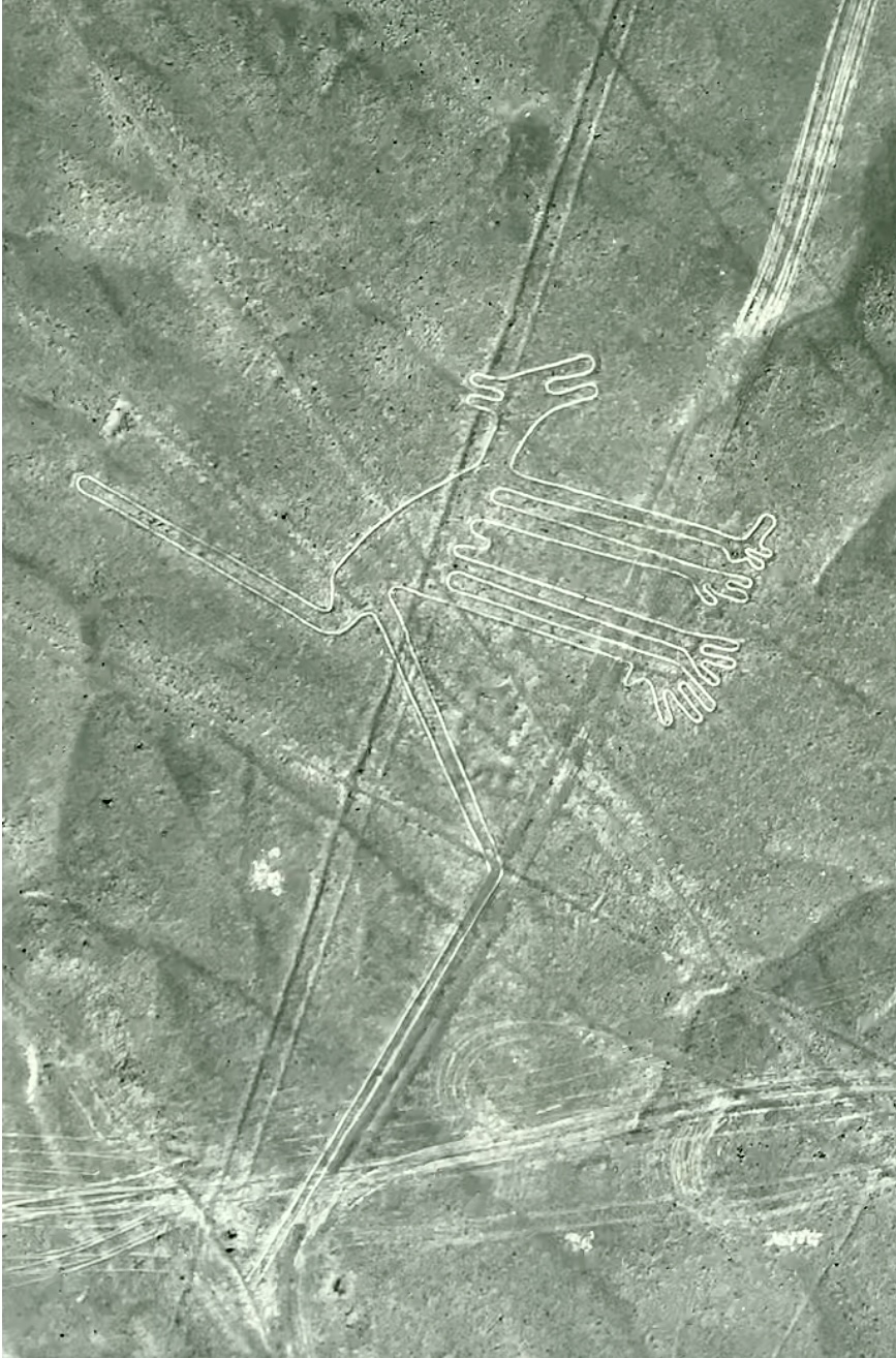
An ancient alien theory also believes they are the remains of old airfields used by a technologically advanced civilisation. There is a biomorph named ‘The Astronaut,’ a human figure thought to be donning a space helmet. However, archaeologists feel it most likely represents a religious or spiritual leader.
Other scientists say the geoglyphs were used as an agricultural calendar to predict the best time to harvest crops and the arrival of the rainy season.
Toribio Mejia Xesspe, a Peruvian archaeologist, was the first to study the lines in 1926. But, it was impossible to identify the actual shapes and forms from the ground level. It wasn’t until the area was seen by a plane from above that the scale and magnitude of the site’s size, quantity, and diversity were realised.
In 1941, American professor Paul Kosok was at the foot of a line when he discovered it was directly aligned with the sunset and the winter solstice. Professor Kosok called the stretch of the high desert “the largest astronomy book in the world.”
German-born Peruvian mathematician Dr Maria Reiche later took over the study of the lines and believed they formed a complex celestial calendar created with highly sophisticated mathematical precision.
Visitors coming from Lima face over a 3-hour bus or car ride to the town of Paracas or Pisco and over 7 hours if travelling directly to Nazca. The route is pleasant, traversing the well-maintained Pan-American Highway along the Peruvian coastline. A private charter flight is the only plane connection to Nazca from Lima.
Once in Nazca, visitors can climb the 43 feet high (13-metre) Mirador Observation Tower, which provides a limited view of two Nazca Line figures; the Tree and Hands.
However, with an overflight tour, Nazca enthusiasts can fully appreciate the size and scale of these geoglyphs. Several tour operators offer flights from the Maria Reiche Neuman Airport in Nazca or the Capitan FAP Renan Elias Olivera Airport in Pisco.
The best time to fly would be to take a flight in the morning, as it can get wildly windy later in the afternoon.
For roughly 90 minutes, the flight will soar 3,000 feet over the high desert of southern Peru. Views of a pale sandy ecosystem and stretches of small peaks and valleys will be beautifully contrasted with the bright blue Peruvian sky.
Shortly into the 90-minute flight, distinct white lines will gradually appear, many crisscrossing each other like a modern airport runway.
Trying to bridge the divide between the past and present, visitors don’t need an archaeology degree to ponder the mysteries of the Nazca Lines. An animal symbol is common throughout the Andes, and monkeys are found in the Amazon – an area with abundant water. Then there are spiders, believed to be a sign of rain, and hummingbirds are associated with fertility.
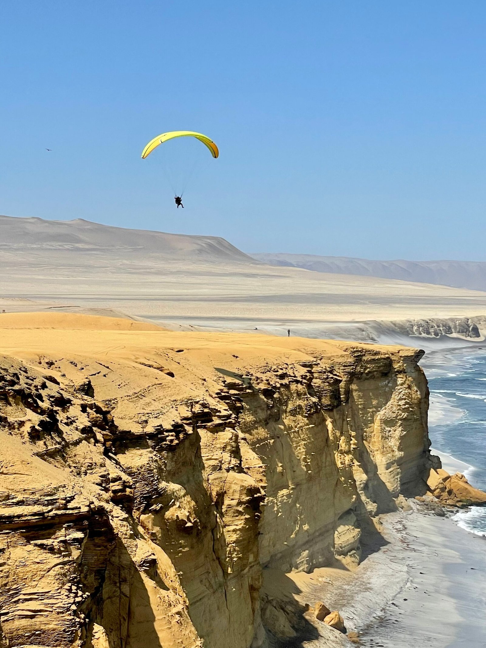
The nearby town of Paracas is a relaxed beach town with an array of restaurants and shops. One of the main attractions is the Paracas National Reserve. The area is stunning, with miles of white sand contrasted against the Pacific blue ocean. It’s an area that provides the unique opportunity to parasail over both the desert and the sea, explore the vast dunes in an all-terrain vehicle, and visit the Ballestas Islands by boat.
The Ballestas Islands are just a short boat ride from the Pacific Coast and are referred to as the mini-Galapagos. Sea lions, Humboldt penguins, and pelicans reside in their natural habitat while thousands of gulls and terns fly overhead. Visitors cannot swim with the animals or walk on the islands but can get very close to them by boat.
On the way, you can spot a geoglyph on the nearby hillside called the Candelabra of the Andes. It has been radiocarbon dating to 200 BCE, the time of the Paracas culture. It’s large enough to be seen 12 miles from the sea and is considered a native plant or the trident of the Incan God, Viracocha.
In 1994, the Nazca Lines were given UNESCO World Heritage status; at that time, only 30 giant etchings had been identified. Recently, researchers used drones and other aerial imaging to discover 168 additional geoglyphs depicting humans, snakes, felines, killer whales, birds, camelids, and several other designs. Archaeologists continue exploring the mysteries of the Nazca Lines, and our understanding will continue to evolve.
Life is full of unknowns, but for travellers exploring ancient sites like these, discovering something about a place or the people who inhabited it gives a voice to ancient cultures from long ago. You will leave with no definitive answers to the mysteries of the Nazca Lines but with an understanding of how travel opens our eyes to the unknown and how much we still don’t know or understand about our ancient past.
Enjoyed the article? Subscribe to access premium content and discover even more amazing travel stories.
| Cookie | Duration | Description |
|---|---|---|
| cookielawinfo-checbox-analytics | 11 months | This cookie is set by GDPR Cookie Consent plugin. The cookie is used to store the user consent for the cookies in the category "Analytics". |
| cookielawinfo-checbox-functional | 11 months | The cookie is set by GDPR cookie consent to record the user consent for the cookies in the category "Functional". |
| cookielawinfo-checbox-others | 11 months | This cookie is set by GDPR Cookie Consent plugin. The cookie is used to store the user consent for the cookies in the category "Other. |
| cookielawinfo-checkbox-necessary | 11 months | This cookie is set by GDPR Cookie Consent plugin. The cookies is used to store the user consent for the cookies in the category "Necessary". |
| cookielawinfo-checkbox-performance | 11 months | This cookie is set by GDPR Cookie Consent plugin. The cookie is used to store the user consent for the cookies in the category "Performance". |
| viewed_cookie_policy | 11 months | The cookie is set by the GDPR Cookie Consent plugin and is used to store whether or not user has consented to the use of cookies. It does not store any personal data. |